TOPOWIN 13.00 Details
Shareware 3.39 MB
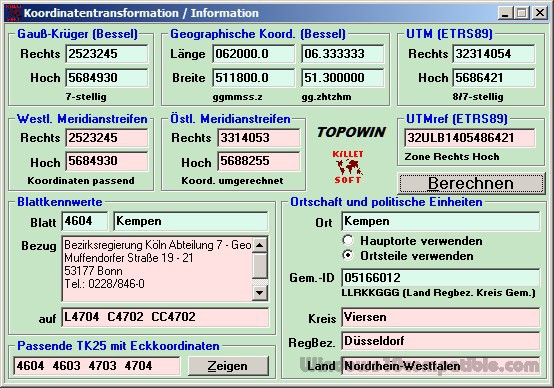
TOPOWIN is a state-wide register of the German topographic cartographies and of localities with geo references in different coordinate systems. It also is a topographic information system. The topographical maps of different standards can be determined by the entering of known parameters or by the direct selection from overview graphics and from sorted lists.
Publisher Description
 TOPOWIN is a state-wide register of the German Topographic Cartographies, the German Basic Cartography and of localities with geo references in different coordinate systems. It is also a topographic information system. In the division of planning and execution of economical and scientific projects frequently topographic documents are used. The program TOPOWIN makes information available of the official topographic cartographies and the German Basic Cartography from the entire national territory in suitable graphic views. It accomplishes different coordinate transformations and inquiries. The program was developed under co-operation of the land surveying authorities of many German Federal States. For the first time in the previous version TOPO (for DOS) and later in TOPOWIN state-wide topographic information were arranged for the data technical evaluation. The program is for consulting engineers, planning authorities and users of topographic maps a useful and versatile tool. The topographical maps of different standards, required for a project, can be determined by the entering of known parameters or by the direct selection from overview graphics and from sorted lists. By the investigation of topographical records on the basis of known places, a data base with more then 105.000 places and residential districts is available. The program TOPOWIN calculates with Gauss Krueger coordinates and Geographic Coordinates refering to the Potsdam Datum (Bessel ellipsoid with central point Rauenberg). It also works with UTM coordinates and UTMRef coordinates in the NATO standard, which refer to the datum ETRS89 (GRS80 / WGS84, geocentric).
Download and use it now: TOPOWIN
Related Programs
ASTRA32 - Advanced System Information Tool
ASTRA32 - Advanced System Information Tool is an ideal solution for providing comprehensive information about the configuration of your system. Not only does ASTRA32 provide a detailed analysis of your system it also offers diagnostics and comes with some powerful...
- Demo
- 20 Jul 2015
- 2.06 MB
UTM Coordinate Converter
UTM Coordinate Converter, converts between various geographic coordinate systems, allowing you to convert between various Latitude/Longitudes systems and the Universal Transverse Mercator (UTM) system. It includes a map that displays the location you converter, as well the map allows to...
- Freeware
- 20 Jul 2015
- 61.96 MB
Puss in the Corner Solitaire
When the game starts 4 aces will be dealt to the center of the table as the start of 4 foundation piles. After that 4 cards will be dealt at 4 corners as the start of 4 waste piles. The...
- Freeware
- 20 Jul 2015
- 656 KB
GCULVERT Cast in place box culvert
It automatically generates the construction drawings of the cast in place box culverts. The culvert consists of one or more rectangular frame pieces, 2 wings or a wing and a fall chamber. Rectangular pieces can be placed in steps to...
- Shareware
- 02 Jan 2023
- 1.7 MB
Crush CPA Study Guide
You Have a 1 in 5 Chance of Passing All 4 Sections of The CPA Exam on the First Try. With the odds stacked against you its too risky not to properly prepare. This guide will take you step-by-step through...
- Shareware
- 21 Sep 2016
- 846 KB